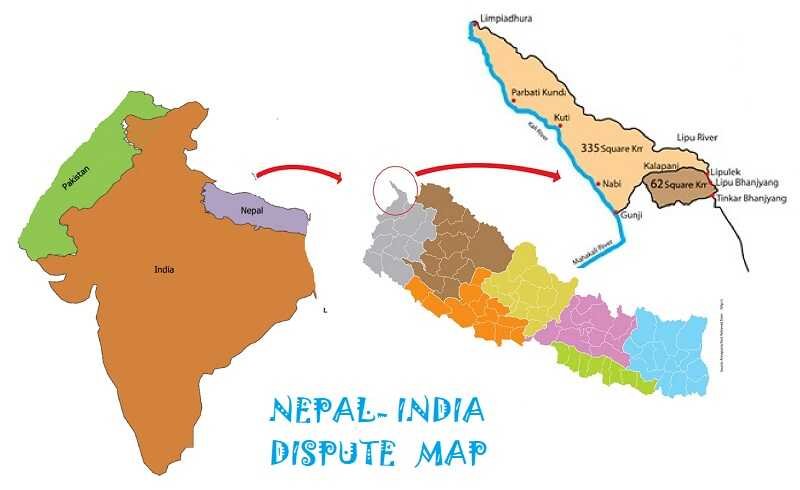
Nepal has issued a new political map that shows the area between India and Nepal — Lipulekh, Kalapani, and Limpiyadhura — under Nepal’s territory. This has increased tensions between the two countries especially after Mr Oli’s comment “Indian virus looks more lethal than the one from China”
The issue erupted when Nepal objected to the construction of roads by India from Dharchulain Pithoragarh to Lipulekh pass near the Nepal-China border. Indian army has had its base in Kalapani since the 1950s. This falls in the route of pilgrimage to Kailash Mansarovar.
The Lipulekh pass is a far western point near Kalapani, an alleged “disputed” border area between Nepal and India. Both India and Nepal claim Kalapani as an integral part of their territory. India claims it is a part of Uttarakhand’s Pithoragarh district, while Nepal sees the part as Dharchula district.
For India, the Lipulekh pass has always been part of the road to Tibet and was mentioned as one of the borders passes for trade in a 1954 agreement with China, which was also reaffirmed in another trade agreement in 2015.

India-nepal border dispute 
India-nepal Kalapani dispute
The Treaty of Sugauli concluded between British India and the Kingdom of Nepal in the year 1816, maps the Mahakali river as the western boundary with India but different British maps showed the source of the tributary at different places which was mainly due to underdeveloped and less-defined surveying techniques used at that time.
The discrepancy in locating the source of the river led to boundary disputes between India and Nepal, with each country producing maps supporting their own claims. Nepal said it has “consistently maintained” that as per the Sugauli Treaty of 1816, “all the territories east of Kali (Mahakali) river, including Limpiyadhura (from where kali river originated), Kalapani and Lipulekh, belong to Nepal”.
According to Prof Rajan Kumar, JNU: “At a technical level, this controversy is about the origin of the river Kali (Mahakali). Nepal claims that this river originates in Limpiyadhura, and not from the stream which comes to Kalapani from the Kali temple, as claimed by India. Nepal shows historical maps of 19th century to support its claims. This claim, however, is disputed by India by showing its own maps. The official map of Nepal did not include these territories up until this decade.”
What is India’s stand?
The official spokesperson of Ministry of External Affairs (MEA), Anurag Srivastava, has termed Nepal’s action `unilateral act’. These areas have always been part of the Indian Territory. Responding to media queries, Srivasatava stated that “Such a move is not based on historical facts or evidence. And such artificial enlargement of territory will not be accepted by India.” India has urged Nepal to resolve the matters through diplomatic dialogues and to create a positive atmosphere.
